National Geographic World Wall Map - Classic (43.5 x 30.5 in) (National Geographic Reference Map)
Product ID: 365309523
🌍43.5 x 30.5 in detailed size
📜Up-to-date political boundaries
🗺️Winkel Tripel projection for accuracy
Desertcart purchases this item on your behalf and handles shipping, customs, and support to Senegal.
🌐 Own the world’s most authoritative map—because your space deserves global prestige.
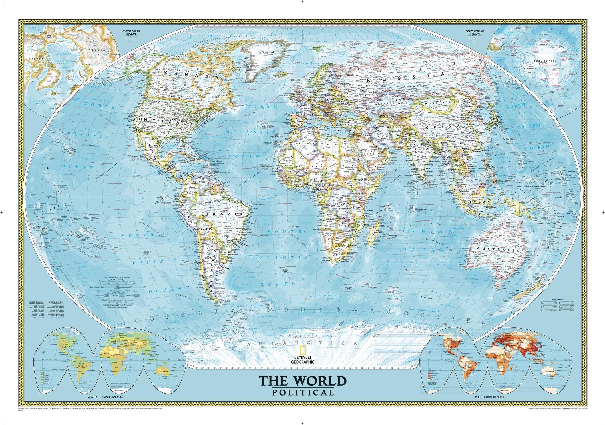
The National Geographic World Wall Map - Classic (43.5 x 30.5 in) is a meticulously researched, up-to-date political world map printed on high-quality paper. Featuring the Winkel Tripel projection to minimize distortion, it highlights international boundaries, cities, and physical features with a vibrant, easy-to-read color palette. Ideal for professionals and map enthusiasts, it arrives rolled for easy framing and display, making it a prestigious addition to any office or home.


| Best Sellers Rank | #209,487 in Books ( See Top 100 in Books ) #27 in World Atlases & Maps (Books) #60 in Geography (Books) #132 in United States Atlases & Maps (Books) |
| Customer Reviews | 4.5 out of 5 stars 289 Reviews |
C**Y
Detailed laminated political world map
Nice quality laminated derailed map. Cartographic details are substantial. This is a durable world map that highlights political divisions instead of physical features. The physical feature, landforms world map is also available separately and highlights natural landform features rather than political boundaries. Both maps serve an individual purpose - one visualizes national boundaries and the other visualizes landform regions like deserts and mountains. Political vs physical world maps.
A**R
Laminated is good
Great laminated map of the world. Incredibly, it includes all seven continents, not like the cheaper competitors that will only give you four or five. Also, the oceans are labeled - fantastic! It also included labels for ALL countries that have vowels in their names. The geographers at NatGeo are really top notch.
S**T
Satisfied customer
It's a nice big map, although you will most likely need to get it framed to hang properly. In Indian terms, it cost about USD 10 more for the framing. It was shipped to India for me in about 10 days. The packaging was simply superb, not a wrinkle on the map that was encased first, in a thin waterproof plastic sheath, then in a stiff cylindrical cardboard tube, then in a large thick cuboidal cardboard container with more than adequate packing material. Absolutely no problems on that front. About the map itself I had some confusion about the size, with different reviews mentioning different sizes. The one is have is 43.5 x 30.5 inches, or 110 x 77 cm. It will reflect light a bit, but that is not a major issue for me. It contains all sorts of information beyond cities and political boundaries... For instance, there is a sub-map of land use and vegetation patterns, another of population density, a list of the 8 largest countries by size (I never realized Algeria was that big), time zones, ocean currents, trade winds, intact submaps of Antarctica and the north pole regions... There is discreet yet prominent National Geographic yellow rectangle branding at the bottom centre, so viewers will know its the real thing. I find it very nice.
D**L
Decent World Map
Great for school homework and helps with global knowledge.
A**A
Yes, go for the laminated!
Very glad I choose the laminated one. My 8yr old loves it! It’s in his bedroom and every day he studies it. He’s always shown interest for geography and this map and size are great. Tip, use blue tack and adjust the height to whoever intended for so that standing can easily read all names, from top to bottom. Also without any furniture right in front so that it can be easily approached.
S**B
Great map!
Exactly what my son wanted for his room. It's large and laminated and updated. Would recommend.
S**N
Best map for my room wall
I bought this map to replace my current paper one that is not laminated. This is way better because i can circle my destinations with whiteboard markers and easily wipe them off thereafter. The fonts are super clear and high-definition, even for the tiny ones. The small fonts is one thing which most other maps fail to print properly. I bought this map because it is by Nat Geo and i trust its quality. I wasn't disappointed when i received it. It is thinly laminated but still good quality and carefully rolled up and shipped to me in an Amazon box full of paper stuffings to protect it from shipping damage. It unrolled well and it did not have strong rolls that hindered me putting it up on my wall. Now i am so happy looking at it each time i walk past my wall. I recommend this medium sized map to anyone who wants one!
D**E
For research
A great tool and location knowledge to track a traveling family member.
F**R
very expensive - poor quality
The paper the map is printed on is very thin - it won't last long on my classroom wall, which is a pity because it was quite expensive. It won't survive grubby fingers or being taken down and put back up again. Bit of a rip-off (excuse the pun).
K**I
Great map, poor lamination.
The lamination is flimsy and very glossy (as opposed to a matte finish, which would have been much more ideal). It has a few visible scuff marks, and the thin lamination means that the edges curl in slightly if you only stick it at its corners. A laminated National Geographic map I had delivered from a local retailer is of much better quality.
M**9
Good map, but does have small print
Good map, but does have small print. It can be a bit hard to read, but still great purchase. We will use it for homeschooling,
A**E
Muster Weltkarte um sich auf dem Globus zurecht zu finden!
Da ich mein Leben lang auf dem Globus unterwegs war, ist es sehr gebrauchsvoll meinen Kinder, Familie und Freunden zu zeigen, wo in der Welt ich mal Fuss gesetzt hatte.
L**U
Excelente compra!
Me encanta el diseño, el tamaño, el nivel de detalle, la tipografía única. Muy satisfecho con la compra
Trustpilot
1 month ago
2 weeks ago