We remain fully operational. Our teams are working around the clock to ensure your deliveries continue safely.

DOWNLOAD THE APP


Copyright © 2025 Desertcart Holdings Limited
DOWNLOAD THE APP


Buy anything from 5,000+ international stores. One checkout price. No surprise fees. Join 2M+ shoppers on Desertcart.
Desertcart purchases this item on your behalf and handles shipping, customs, and support to Senegal.
🌐 See the world without distortion—map your knowledge with clarity and style!
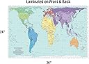
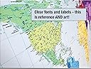
The Updated Peters Projection World Map (36" x 24") offers the most proportionally accurate depiction of global land masses, ensuring true country size comparisons. Laminated with a satin finish, it is waterproof, fade-resistant, and dry-erasable, making it perfect for educational, professional, or personal use. Featuring a multi-colored design for easy continent and country identification, this map is the preferred choice of UNESCO and aid agencies, and is proudly produced by a family-owned small business in Charlotte, NC.
| ASIN | B09BDHHK2X |
| Best Sellers Rank | #42,415 in Office Products ( See Top 100 in Office Products ) #104 in Wall Maps |
| Brand Name | South of Kings |
| Color | Multi |
| Customer Reviews | 4.8 4.8 out of 5 stars (192) |
| Item Dimensions L x W | 36"L x 24"W |
| Map Type | World |
| Paper Finish | Satin |
| Paper Size | 36 x 24 Inches |
| Unit Count | 1.0 Count |
A**R
Updating with this 2021 map was worth it
For several years I enjoyed my prior somewhat larger version of the Peter's projected map that was also printed in various colors & laminated. This updated map occupies the same area where I enjoyed my prior reference. A smart looking map like no other on the market. I would fully encourage those in need of a up-to-date (2021) wall map to take notice of and would like to purchase, well worth the investment. Good stuff.
J**D
Love this Map
If you like Maps this is the one you want. It shows the true size country to country. comparison. It’s certainly educational and quite interesting to see. The color and the printing were perfect. I wouldn’t change anything.
C**T
perfect size for my wall
Good quality great print easy to read makes it perfect for me and my husband both in our late 70's
E**R
Great map
Got it for my kid's bedroom. He asks a lot of questions about Earth and now we have an accurate map to help answer them! My only wish would be for it to have a Key, but honestly it's pretty self explanatory even with one.
G**1
🌍The world must know! ✊🏾
***My students from the African diaspora have become inspired and emotionally moved after seeing this map in my office. The future generation will KNOW THE TRUTH!!!!
R**R
Just as advertised and well-made
This map is excellent; it depicts countries and continents true to actual/relative size. Very interesting and illuminating. It is very well-made, arrived promptly, and was easy to unroll and mount.
S**N
Helpful for classrooms
I have ordered a bunch of these for classrooms at my school. They are a great size - just big enough and not too big.
J**R
areas accurate, shapes distorted
The Peters Projection accurately shows the relative size of different countries (who knew south american countries were so big!) The cost of this accuracy is that equatorial countries are severely squashed horizontally, while polar countries are squashed vertically. If you live in one of these countries, you might find it unpleasant to look at the deformed shape of your motherland, like looking at your face in a funhouse mirror. Since very few of us will use this map to navigate on the high seas, there is no need to religiously keep the meridians parallel. The classic schoolroom world map is still the best, either the version with curved edges or the version with gaps in the oceans in order to spread the globe out flat. The Mercator is inexcusable, yet it continues to dominate image searches of world maps.
Trustpilot
3 days ago
1 week ago